
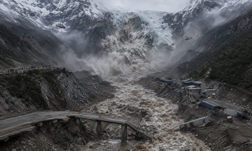
KATHMANDU, Nepal — Rescue teams searched through deep mud and shattered settlements on Thursday after the collapse of a Himalayan glacier sent a high-speed torrent through valleys along the Nepal-China border, killing at least 392 people and leaving nearly 1,500 unaccounted for.
Nepalese authorities reported 389 confirmed deaths and 910 missing, while Chinese officials listed three deaths and 558 people missing in Tibet’s Gyirong County. The figures remain provisional and may include people stranded in communities cut off by destroyed roads and communications—not only those known to have been swept away. Radio Nepal, citing Nepal Police, said bodies had been recovered across eight districts, some more than 100 kilometers downstream.
A Mountain Gave Way
Satellite and seismic evidence indicates that part of a glacier and the underlying rock mass collapsed near Langtang Lirung, a roughly 7,000-metre Himalayan peak. The avalanche plunged into the Lhende Khola catchment, gathering glacial sediment, boulders and river water before surging into the Bhote Koshi and then the Trishuli river system.
Chinese geologists estimated that parts of the debris flow moved at about 50 meters per second—roughly 180 kilometres an hour—leaving communities below almost no time to escape. The river reportedly rose by seven to nine metres in just 30 minutes at downstream monitoring points. Reuters reported that bodies and debris were carried more than 100 kilometers into Nepal’s plains.
The destruction resembled a tsunami, but the event was technically a cascading ice-rock avalanche, debris flow and flash flood. It buried buildings and vehicles, erased sections of road and destroyed bridges, hydropower facilities and the border complex at Gyirong.
Early reports described a possible earthquake. The United States Geological Survey later concluded that the recorded seismic signal had most likely been generated by the collapsing mass of ice and rock—not by a tectonic earthquake that triggered it. Scientific analysis of satellite imagery similarly placed the initial failure high on the mountain.
Why So Many People Were in a Remote Valley
Although the upper valley is sparsely populated, it is not isolated from regional commerce or religious travel. The narrow Rasuwagadhi-Gyirong corridor is one of the principal overland connections between Kathmandu and Tibet and an increasingly important link in China’s South Asian trade network.
Truck drivers, customs officers, construction workers, traders and hotel employees routinely move through the crossing. At the same time, hundreds of international pilgrims were travelling toward Mount Kailash and Lake Manasarovar, sacred to Hindus, Buddhists, Jains and adherents of the Bon tradition.
On the Nepalese side, local pilgrims were heading toward Gosaikunda Lake for Janai Purnima. The convergence of religious groups, tour buses and ordinary border traffic helps explain why a disaster in such a narrow mountain corridor produced an unusually large list of missing people.
More than 500 foreigners from over two dozen countries were reported missing in Nepal alone. China said 260 foreign nationals were among those unaccounted for in Tibet. The totals are complicated by separate Nepalese, Chinese and tour-company lists, possible duplication and the inability to contact groups stranded beyond damaged telecommunications networks.
Rescue Efforts—and the Risk of Another Flood
Nepal deployed more than 4,300 police personnel, along with soldiers, helicopters and local rescue teams. Prime Minister Balendra Shah traveled toward the affected districts, while Nepal’s National Human Rights Commission called for better coordination and urgent provision of shelter, drinking water, food, health care and sanitation. At least 466 people had been rescued or found injured, according to Nepal’s public broadcaster.
Chinese Premier Li Qiang traveled to Gyirong as emergency crews attempted to clear the only major access road to the destroyed border area. China’s official Xinhua News Agency reported 558 people missing on the Tibetan side.
The danger has not passed. Debris has blocked waterways and created unstable lakes on both sides of the border. Nepalese authorities warned downstream communities to leave riverbanks, while China said roughly three million cubic metres of additional water could enter one newly dammed lake within days, raising the prospect of another sudden breach.
The International Federation of Red Cross and Red Crescent Societies launched an emergency appeal for 25 million Swiss francs, estimating that approximately 93,000 people may have been affected. Immediate priorities include clean water, temporary shelter, medical support and access to isolated settlements.
A Warning From a Warming Himalaya
Scientists cautioned that no single disaster can be attributed to climate change before a full investigation. But warming temperatures can melt the ice that supports fractured mountain rock, fill crevasses with water and weaken permafrost that acts like geological cement.
Ground temperatures near the collapse site had reached their highest level in two years shortly before the disaster, according to researchers cited by The Guardian. Glacier-loss rates in the Langtang region have also accelerated sharply since the 1960s.
The catastrophe therefore exposes more than a local emergency. It reveals a widening mismatch between rapidly destabilizing Himalayan terrain and the limited monitoring, cross-border warning systems and evacuation infrastructure protecting the people and economic corridors below.
Casualty figures are provisional as of late Aug. 27 and are expected to change as isolated areas are reached and national lists are reconciled.
Sources: Radio Nepal