
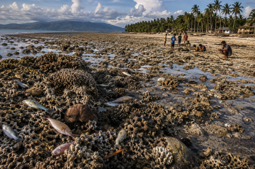
Powerful 7.8-Magnitude Quake Reshapes Southern Coastline
MANILA, Philippines — A powerful earthquake that struck the southern Philippines earlier this week has not only claimed dozens of lives but also dramatically altered the region’s coastline, raising sections of the seabed by as much as two meters and exposing extensive coral reefs and marine habitats previously hidden beneath the ocean surface.
According to Philippine environmental and geological authorities, the magnitude-7.8 earthquake that struck Mindanao on June 8 resulted in a phenomenon known as coastal uplift, in which tectonic forces push sections of the Earth’s crust upward. The event extended portions of the shoreline by up to 200 meters in several coastal communities in Sarangani and Davao Occidental provinces.
The latest figures from the National Disaster Risk Reduction and Management Council indicate that at least 61 people have died, while approximately 40 remain missing, making it one of the deadliest earthquakes to strike the country in recent years.
Coastline Transformation Reveals Extent of Tectonic Movement
Scientists from the Philippine Institute of Volcanology and Seismology (PHIVOLCS) reported that movement along the Cotabato Trench, a major offshore subduction zone located roughly 50 kilometers from southern Mindanao, caused significant vertical displacement of the seabed.
“Part of the coastline was pushed upward, exposing marine areas that were previously submerged,” PHIVOLCS said. Preliminary mapping suggests uplift reached approximately two meters in some locations.
The Cotabato Trench is one of the most seismically active regions in Southeast Asia and has generated numerous earthquake sequences over the past decade. Earlier this year, thousands of smaller tremors were recorded in the same tectonic system, prompting warnings from geologists about accumulating stress along the fault zone.
Environmental Damage Raises Alarm
Initial field assessments conducted by the Department of Environment and Natural Resources (DENR) found extensive stretches of exposed coral reefs, seagrass beds and shallow marine ecosystems.
Photographs released by regional environmental authorities showed coral formations stranded above the waterline alongside dead fish and other marine organisms unable to survive the sudden change in habitat.
Marine biologists warn that while coastal uplift is a natural geological process, its ecological consequences can be severe. Coral reefs and seagrass ecosystems provide critical breeding grounds for fish species, support coastal fisheries and serve as natural barriers against storm surges.
“The sudden emergence of reef systems can trigger localized ecosystem collapse if marine organisms are unable to adapt quickly,” environmental experts said, noting that recovery could take years depending on the extent of exposure and subsequent weather conditions.
Part of a Wider Pattern Along the Pacific Ring of Fire
The Philippines sits within the Pacific Ring of Fire, a horseshoe-shaped zone of intense tectonic activity responsible for some of the world’s largest earthquakes and volcanic eruptions.
Recent international studies suggest that climate-related sea-level rise may increase the vulnerability of coastal communities to earthquake-induced changes, although scientists emphasize that tectonic events themselves remain driven by geological rather than climatic forces.
Seismologists note that coastal uplift following major earthquakes has been observed elsewhere in the region, including in Indonesia, Japan and New Zealand. Similar events have historically provided valuable insights into long-term tectonic processes and earthquake forecasting.
Recovery Efforts Continue
Government agencies continue search-and-rescue operations in affected areas while engineers inspect roads, bridges and public infrastructure damaged by the quake.
Environmental teams have also begun detailed surveys to determine the full extent of ecological damage along Mindanao’s southern coastline. Officials caution that assessments may take weeks due to the size of the affected area.
For many residents, however, the most visible reminder of the earthquake is the transformed shoreline itself — stretches of newly exposed land where ocean waters once stood, offering a stark illustration of the immense geological forces operating beneath the Philippine archipelago.
Analysis
Experts say the Mindanao earthquake highlights the dual challenge facing disaster-prone nations: managing immediate humanitarian crises while addressing longer-term environmental consequences. The event demonstrates how major seismic activity can rapidly reshape coastal geography, affect fisheries and biodiversity, and alter local economies dependent on marine resources.
As scientists continue monitoring aftershocks and measuring tectonic displacement, the earthquake is likely to become a significant case study in both earthquake science and coastal ecosystem resilience across the Asia-Pacific region.